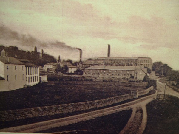
cummersdale mills continued..........
After 1854, another row of back-to-back houses was built adjacent to the earlier row, a lane existed between the two rows, with a water pump at the lane head.
Because the village has now gone, I will attempt to discribe how it was;-
As you walk down the road from High Cummersdale toward the river Caldew you pass Hill House on your left. As you near the bottom of the hill a short distance passed Hill house there is a small garage on the right. Attached to the side of the garage is a small pig sty, which belonged originally to the miller. Between the pig sty and the next building , which was the corn mill, was a cobbled roadway which led to other buildings behind the corn mill. The first part of the corn mill which faced outwards to the road was the loading /unloading bay which was covered by a canopy roof where grain and flour could be loaded and unloaded out of the elements. The corn mill was three storey's high with a hoist protuding from the upper floor for unloading the grain into the mill. On the opposite side of the road from the mill buildings was a blacksmiths shop and a shafting house for the Waverly turbines. Back at the corn mill side of the road, and attached to the mill building was Mill House. This large house was built over the mill stream. At one side was the water wheel which, when the sluice was opened drove the shafting for the corn mill. The front of the house faced in the direction of the river. It had many rooms and toward the rear of the house was the wash house. A trap door in the floor of the wash- house revealed the mill stream below. Water from the mill stream was used for washing, except in flooding conditions. Another long room attached to the wash-house was originally the milking parlour. Even as late as 1871, at Mill House, Joseph Dalton is recorded in the census as head of the household and his occupation is given as a Farmer (160 acres) and a Miller. Mary Dixon,30, was his house keeper, Isabella Irving, aged 35, was the dairy maid, Richard Moor was the indoor farm servant, two millers also lived at Mill House. The mill stream ran underneath the road after passing under neath Mill House, it then turned a sharp left, then right over the by-fall ,driving the turbines. It originally drove a large water wheel which powered the cotton mill machinery. Continuing down the corn mill side of the road, the next buildings were two terrace houses with their fronts facing, and close to the road edge. Each house had its own orchard and garden at the rear. These were originally the cotton mill managers houses.
The next buildings on the right were two rows of back-to-back houses, but on the first row facing the road was the shop and post office. In the 1890's William Forsyth was the grocer; in 1901 William Smith took over the shop, until about 1910. Luther Andrews took over the running of the shop until 1935, when they demolished the front row of houses and the shop. In 1938 John Beaty, is recorded as the shop keeper. Opposite the front row of houses and stretching back along the road as far as opposite Mill House were two cotton mills. Next to the cotton mill, as the road turned left at the river toward the Print-works a building on the corner housed the wash-house and toilet block for the residents of the bottom village. Once past these facilities was the entrance to the cotton mill yard. Entering the mill yard, on the right as you entered was the school building (1860's to 1914), directly opposite the school was a boiler house and attached to it was a cottage, both buildings backed onto the mill stream where it emerged from the Waverly as mentioned earlier There was at one time a gasometer further along the cotton mill yard. Back outside the cotton mill yard gates, and turning left heading toward, after a short distance was the bridge and ford across the river to Blackwell. The print-works which is still there is further along.
Back at the bottom village, but this time turning right when reaching the river, there were two clay and cobble cottages facing the river which were originally dye-house workers cottages. These two cottages stood at the head of the lane between the two rows of back-to-back houses. Moving along the road there was a cobbled lane along the front of the back row of houses, which faced the garden allotments and a drying green. At the other side of the cobbled lane was a sandstone built house which became the police station. Just past the police station was the entrance to the allotments and drying green, later a pair of swings were erected for the children. Moving further down the road with the river on the left, on the right was the entrance to the dye-works and the pathway leading into the dye-works yard and buildings. This included the dye-house managers house which was on the second floor, above workshops. Back out to the road ,opposite the dye-works entrance was a foot bridge across the river. This bridge was erected shortly after the Carlisle race course was opened to allow the racegoers who travelled from West Cumberland and Carlisle by train to Cummersdale station and enter the racecourse by the back door , as it were. A turnstile existed at the other side of the railway just through the archway . The footbridge across the river belonged to the Carlisle racecourse committee. By the 1940's the bridge had got into a bad state of repair, it was demolished in 1948, although the concrete anchor blocks on either side of the river still exist. Continuing along the road , once past the dye-house walls is the railway station goods yard on the right, and directly in front is the railway bridge across the river. Just to the right of the bridge a stone stairway lead to the passenger station. Another stairway to the other platform existed just under the bridge on the right. Following the river and road round the bend, was the coal depot with its vaults, weigh bridge and small office. The coal vaults were supplied with coal via a railway siding coal drop. Just past the coal depot was the station masters sandstone built house.
Just past the stationmaster's house it was possible to see the mill stream before it passed behind and under all the buildings and premises I have mentioned. From this point the mill stream was open all the way to the sluice gates at the bay head of the river. The gates were lifted or lowered to control the water flow down the mill stream. As you follow the millstream toward the bay, the land to the left and land further on above the bay was at one time a rifle range from 1862. There was also a greyhound racing track which alternated its site between the rifle range and a small field in between the mill stream and the railway. Another bridge existed above the bay, erected to assist rifle range competitors, as the targets were across the other side of the river Caldew. Throughout the century the bridges were damaged by floods, and of course the bottom village and the factories also suffered from floods.
In 1903, Dalton's, who owned the corn mill, cotton mill and most of the houses, had decided to sell up. It was Edmund Stead, the Print-works owner who purchased the whole of the estate, including the 39 workers houses. As part of the preparation for the sale, a list had been prepared of the cottages and the rents being paid by each tenant. The list gives the official names of each row of houses. The front row which faced the cotton mills and the road was named Mill Street, the back row facing the drying green and allotments was named Green Terrace, the few houses facing the river was called Caldew Terrace, and the two rows facing each other across the lane was named Garden court. One of the houses was used as Mission rooms, (Band of Hope / Welcome).
The village was a close-knit community, and remembered as a nice place to live, once a month families would gather in the bottom village and march up to the church in the top village. This was the church parade. The allotments were also an important part of village life, with great rivalry between the men folk.
By the early 1930's, the Carlisle Rural District Council had decided the houses at Cummersdale Mills a clearance area. The Council intended to move the tenants from Cummersdale Mills to new houses which were to be built at Blackwell, and had already approved plans for 36 new houses at a cost of £11,675. But the residents did'nt want that, especially not moving to Blackwell ! They were up in arms, and a meeting was called. At a parish meeting it was suggested that Cummersdale Mills be declared an improvement area, and not a clearance area, but this was not accepted. Other alternatives were suggested, including building houses at High Cummersdale; the field behind the school was put forward as a possible site. One of the stumbling blocks to building at High Cummersdale was the lack of sewers. The argument raged for sometime. The end solution was to knock down the front rows of houses and convert the remaining row into larger, knocked -through dwellings with inside bathroom and toilet. The remaining row was named Garden Terrace. By 1939, new council houses had been built in High Cummersdale. Eventually all the tenants were either rehoused in company houses in the top village or in council houses. The corn mill and Mill House were knocked down along with the blacksmith shop, the old Waverly shafting house and the Waverly building itself. The Dye-works, although not used for dyeing since 1913, was used as a storage area for SteadMcAlpin's machinery, etc. A fire gutted most of the building in the 1970's, the rest were demolished shortly afterwards.
The remaining row of houses (Garden Terrace) and the couple of houses facing the river were eventually demolished in the early 1970's. The land stood derelict until 1991, when, because in 1990 the weir across the river further upstream collapsed, a lagoon had to be constructed in order to supply water to Stead McAlpin print-works.
It is apparent that the village was a busy little community with its mills and factories, and its busy station and coal depot, not forget the comings and goings of the rifle range participants and later the race-course crowds. The mill girls and print-works employees would come and go daily, and of course Cummersdale has always been a popular walk from Carlisle. The mill school would have added to the already busy little village.

The cotton mill/ Block printing building being demolished in 1991, with the cotton mill school building centre left, with pointed roof. The river Caldew is on the left out of shot.
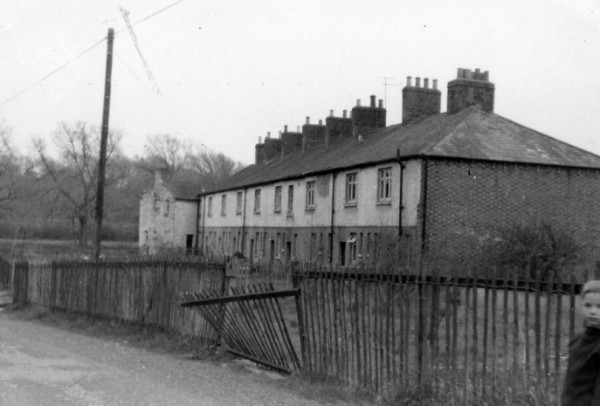
The one remaining row of houses after the demolition of the front row. This row was demolished in the 1970s.
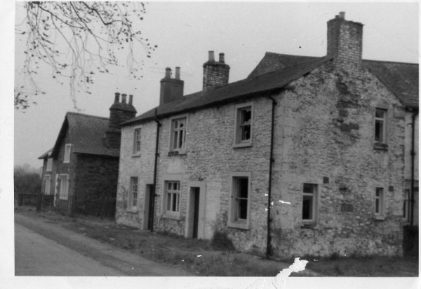
The two end houses and the Police house facing out over the river Caldew
Cummersdale also had a rifle range just along the river from the village, it was started by the Cumberland Volunteer Rifle Corp's in 1862, and the range was still going until 1964.
Cummersdale Mills village was beside the river, and Bridges played an important part in order that people could cross to the other side at times. There was also footpaths at both sides of the river and beyond that needed access. The bridges across the Caldew have a history of being washed away, and eventually not rebuilt. The most important footbridge crossing the Caldew is the one leading to Blackwell. This bridge has been replaced several times because of flood damage. My first reference to it being washed away was in 1809, when a great flood damaged and washed it away. The bridge that replaced it was also replaced in 1930, the foundations for this bridge was the rubble from the old Spinners Arms. This bridge also had a Ford at one side, this was to allow a horse and trap to cross to Blackwell. Another bridge existed opposite the Dye-Works, and in line with the tunnel under the railway leading to the Race course. This bridge was extensively used during Race meetings at Blackwell. People from West Cumbria and Carlisle alighting from the train at Cummersdale Mills station and using the bridge to cross the river, then through the tunnel and the through a turnstile at the other side and into the course. (this bridge can be seen on the previous page). The railway bridge has just recently been renovated (2012). There was two further bridges that existed, one was opposite the rifle range just before you reach the red cliffs, this was used by walkers and members of the small bore rifle club. Another bridge existed above Cummersdale Bay water fall, the anchor pins still exist in the wall at the Cummersdale side. This bridge was used by the numerous people and organisations that used the rifle ranges from 1862, the target butts were across the river near the red cliffs.
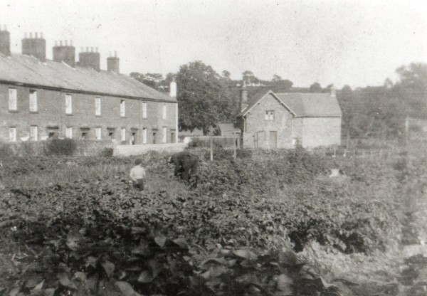
The allotments behind the bottom village houses with the police house on the right.