Cummersdale parish is situated 2 miles South West of Carlisle,Cumbria, it is bordered by Orton parish to the West, Dalston parish to the South, and the river Caldew borders the eastern boundry.
The parish retains its rural character with several farms and open farm lands.
Three villages exist within the parish, Newby West and Garden village to the West and High Cummersdale village on the ridge above the Caldew valley to the East.
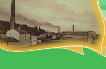
An earlier village existed beside the Caldew but it was finally demolished in the 1970's, leaving only Hill House and the Print-works.
The parish once extended to Shaddongate but with the City of Carlisle expanding, the modern parish has shrunk.
The church of St James serves the parish and a church hall exists in High Cummersdale village.
Only one Public House exists in the parish, the Spinners Arms.
A bus service runs to and from the village, via Carlisle & Dalston. The West of the parish is served by the Whitehaven/Wigton bus service
Although the Carlisle to Maryport railway passes through the Eastern part of the parish the service is no longer available to parishioners..